
फायल:Bhutan CIA WFB 2010 map.png
हाच्या परस वयले बारिक्साय उपल्बद ना
Bhutan_CIA_WFB_2010_map.png (326 × 350 चित्रतत्व, फायलीचो आकार: 16 KB, माइम प्रकार: image/png)

|
This map image could be re-created using vector graphics as an SVG file. This has several advantages; see Commons:Media for cleanup for more information. If an SVG form of this image is available, please upload it and afterwards replace this template with
{{vector version available|new image name}}.
It is recommended to name the SVG file “Bhutan CIA WFB 2010 map.svg”—then the template Vector version available (or Vva) does not need the new image name parameter. |
सारांश
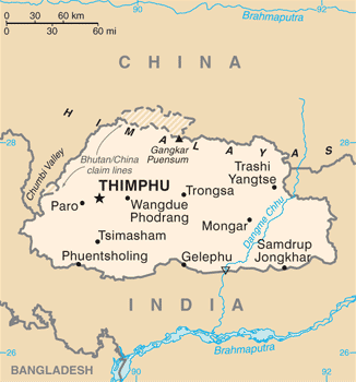
| वर्णन | Bhutan map from CIA World Factbook (since June 24, 2010) |
| तारीख | |
| स्रोत |
CIA World Factbook, converted from original GIF format |
| लेखक | United States Central Intelligence Agency |
| Other versions |
|
परवांगी
This image is in the public domain because it contains materials that originally came from the United States Central Intelligence Agency's World Factbook.
|
 |
फायलीचो इतिहास
त्या वेळार फायल कशी आशिल्ली तें पळोवपाक त्या तारीख/वेळाचेर क्लिक करात
| दिस / वेळ | ल्हान-इमाज़ | परिमाण | वापरपी | शेरो | |
|---|---|---|---|---|---|
| आताचें | 01:10, 7 जुलय 2017 | | 326 × 350 (16 KB) | Ras67 | cropped, opt. |
| 17:26, 12 मे 2015 |  | 330 × 354 (52 KB) | Evolt | Updated to version as of April 24, 2015 | |
| 17:47, 22 ऑगस्ट 2011 |  | 330 × 354 (18 KB) | Zyxw | =={{int:filedesc}}== {{Information | Description = Bhutan map from CIA World Factbook ([http://web.archive.org/web/20100704230847/https://www.cia.gov/library/publications/the-world-factbook/geos/bt.html since June 24, 2010]) | Source = CIA World Factbook, |
फायलिचो वापर
भुमंडळ फाइलीचो वापर
सकयल दिल्ल्यो विकी ही फायल वापरतात
- ace.wikipedia.org चेर जाल्ले वापर
- af.wikipedia.org चेर जाल्ले वापर
- als.wikipedia.org चेर जाल्ले वापर
- ar.wikipedia.org चेर जाल्ले वापर
- as.wikipedia.org चेर जाल्ले वापर
- bcl.wikipedia.org चेर जाल्ले वापर
- bh.wikipedia.org चेर जाल्ले वापर
- bjn.wikipedia.org चेर जाल्ले वापर
- bn.wikipedia.org चेर जाल्ले वापर
- ca.wikipedia.org चेर जाल्ले वापर
- cy.wikipedia.org चेर जाल्ले वापर
- da.wikipedia.org चेर जाल्ले वापर
- de.wikipedia.org चेर जाल्ले वापर
- de.wiktionary.org चेर जाल्ले वापर
- dv.wikipedia.org चेर जाल्ले वापर
- dz.wikipedia.org चेर जाल्ले वापर
- en.wikipedia.org चेर जाल्ले वापर
- en.wiktionary.org चेर जाल्ले वापर
- eo.wikipedia.org चेर जाल्ले वापर
- es.wikipedia.org चेर जाल्ले वापर
- eu.wikipedia.org चेर जाल्ले वापर
- fa.wikipedia.org चेर जाल्ले वापर
- fi.wikipedia.org चेर जाल्ले वापर
ह्या फायलीचें वैश्वीक वापरांची चड म्हायती पळयात.